| +91-612-2256999 | fmisc_bihar@yahoo.co.in | Site Map |
 |

|
| Home | About Us | WRD | River basin Map | Contact Us | Rainfall Forecast |
|
“GIS is a system of hardware, software and procedures designed to support the capture, management, manipulation, analysis, modeling and display of spatially referenced data for solving complex planning and management problems.”
- USGS (United States Geological Survey) (1997)
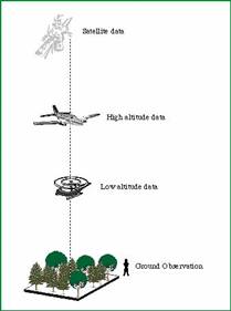
-Simonett, D.S. (1983) Remote Sensing Systems offer four basic components to measure and record data about an area from a distance. These components include the energy source, the transmission path, the target and the satellite sensor. Remote sensing provides important coverage, mapping and classification of land cover features, such as vegetation, soil, water ,forests etc.
The Indian region experiences a wide variety of weather systems such as the monsoons, tropical cyclones, western disturbances and heavy rainfall episodes involving severe thunderstorms. In order to study these systems, the MM5 model is run at a nested 90, 30 and 10 km resolutions on realtime basis over the Indian region on a CRAY-SV1 machine. Mesoscale Model
Using high-speed computer to tackle the computational demand, numerical weather prediction (NWP) is the technique used to forecast weather by solving a set of equations within a numerical model that describes the evolution of meteorological variables representing the atmospheric state. These variables include temperature, wind, pressure and moisture content.
(A) Statistical methods Multi tributary Difference in Gauge model (B) Deterministic methods Unit Hydrograph based models: In India, the applications of unit hydrograph technique are restricted to the catchments of sizes less than 5000 Sq. Km. However, for the catchments of sizes more than 5000 Sq. Km., a network model is developed. In this model the catchment is divided into sub-catchments and the main river is divided into sub-reaches, considering the two consecutive nodes. The nodes are the points where the tributary of the sub-catchments join the main river. The principle of unit hydrograph is applied for converting the excess rainfall to direct surface runoff for each sub-catchment considered as lateral flow to the river and the flood routing technique is used for routing the direct surface runoff at the upstream node through the river sub-reaches up to the downstream node. The computations are performed for the network model structure to estimate the direct surface runoff at the outlet of the catchment. HEC-1 model has an option of the network model simulation using these concepts. This model uses the unit hydrograph technique with constant loss rate to forecast the runoff. Forecasting is accomplished by re-estimating the unit hydrograph parameters and the loss rate parameters as additional rainfall runoff data are reported and using these updated parameters the future flows are estimated for forecasting. Gosain (1984) has used a Unit Hydrograph based real-time flood forecast model on River Yamuna. The same will be used on Bagmati system. SWAT is the acronym for Soil and Water Assessment Tool, a river basin, or watershed, scale model developed by Dr. Jeff Arnold for the USDA Agricultural Research Service (ARS). SWAT was developed to predict the water and sediment yield in large complex watersheds with varying soils, land use and management conditions. SWAT is a continuous time model. The model has a real-time flood forecasting component also. The present version of the model has a interface on ArcGIS. The model is a public domain model HEC-RAS is an integrated package of hydraulic analysis programs, in which the user interacts with the system through the use of a Graphical User Interface (GUI). The system is capable of performing Steady and Unsteady Flow water surface profile calculations, and will include Sediment Transport and several hydraulic design computations in the future. MIKE 11 cross-section data option allows the user to import data from the MIKE11/Flood Program after converting to Raw Text file format. MIKE 11 is a one–dimensional river hydraulics model developed by Danish Hydraulic Institute but is a licensed software. This model can also be used but needs to be procured. ANN Model Another class of Black Box models in the form of Artificial Neural Network (ANN) has been introduced in modeling real time problems wherein the nonlinear relationship between the rainfall and runoff process is modeled. The use of ANN in real time flood forecasting is of very recent origin and shall be used on the Bagmati basin.
|
|
