| +91-612-2256999 | fmisc_bihar@yahoo.co.in | Site Map |
 |

|
| Home | About Us | WRD | River Basin Map | Contact Us | Rainfall |
|
Background of Flood Management Information System (FMIS), Bihar Flood Management Information System, Bihar finds its genesis in the brainstorming meeting on Jan 18, 2006 in which the Government of Bihar (GoB) and the World Bank agreed on a water sector partnership matrix and action plan in three time horizons. In the short term it was proposed to improve the technical and institutional capacity of the State of Bihar for flood management, introducing the extensive use of modern information technologies developing and implementing a comprehensive Flood Management Information System (FMIS) in priority areas. After successful completion of FMIS Phase I administrative approval for FMIS Phase II with estimated cost of 825.00 Lakhs was accorded on 18-1-2011. The Approval statement state that
Government of Bihar accorded the administrative approval for the establishment of Flood Management Information System with the estimated cost of Rs 261.60 lakhs on 22nd January 2007. The approval statement states that: ^^Mh0,Q0vkbZ0Mh0 (Department For International Development, UK), fo'o cSad dh lgk;rk ls ck<+ lwpuk izca/ku iz.kkyh dh LFkkiuk ds fy, ;kstuk izkDdfyr jkf'k 261-60 yk[k :0 dh iz'kklfud Lohd`fr rFkk blds v/khu fo'o cSad ds xkbZM ykbZu ds izko/kkuksa ds vuqlkj vf/kizkfIr ;kstuk dh Lohd`frA** After successful completion of FMIS -I, administrative approval for FMIS-II with estimated cost of 825.00 Lakhs was accorded on 18-01-2011.
Flood Management Improvement Support Centre (FMISC) Office order of Water Resources Department, Government of Bihar bearing number – ck<+ iz0lw0iz0dks0&05@2006&491 fnukad&05@03@07 issued following the administrative approval envisages the creation, structure and function of the Flood Management Information System Cell. Extract of the Annexure-I of the office order is appended below. “A Flood Management Information System Cell (FMISC) has been created under the overall supervision of Chief Engineer (CE), Monitoring and Planning, in Water Resources Department (WRD), GoB, and under Superintending Engineer (SE), Flood Monitoring Circle, to develop and operate the Flood Management Information System (FMIS) with technical assistance from the World Bank. Presently, one Executive Engineer as In-Charge, and six Assistant Engineers (and one peon) have been deputed to FMISC. As interim support, five contract professional staff (one remote sensing specialist, one GIS specialist, one web manager, one Disaster Management Specialist, and one Database Specialist) will also be positioned. The contract staff would be funded under DFID grant.” Thereafter Flood Management Cell was upgraded as Flood Management Improvement Support Centre (FMISC) with Joint Director as office head and E & C (North) as administrative head by WRD notification 5/ Mh0-4-10-01/2007-551 and 1039 dated 30-06-10.
Functions of Flood Management Improvement Support Centre. Main functions of FMISC are listed below.
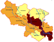
Establishment of Flood Management Improvement Support Centre ( FMISC ) - Directorate as multidisciplinary centre. Flood Management Improvement Support Centre (FMISC) was established vide WRD Notification no-5/डी-4-10-01/07-551 dt 29-03-2010 after approval of the Chief Secretary, Government of Bihar. FMISC is under direct Administrative control of Engineer in Chief (N) and its structure vide the above Notification annexure-5 is as below:- Joint Director – 1 post Deputy Director – 2 posts Assistant Director – 6 posts Junior Engineer – 1 post Accountant – 1 post Correspondence Clerk – 3 posts Steno Typist – 1 post Typist – 2 posts Account Clerk – 2 posts Draftsman – 1 post Photocopier – 1 post Driver – 4 posts Peon – 6 posts Treasure Guard – 1 post Chaukidar – 2 posts Total – 34 posts At present few Engineers are working in FMISC on deputation. FMIS- PHASE- I The FMIS in the first stage covered the focus area from Burhi Gandak River in the west to Kosi River in the east in North Bihar that is most flood prone area in the State. This included 11 districts i.e. East Champaran, Sheohar, Sitamarhi, Muzaffarpur, Madhubani, Dharbanga, Samastipur, Supaul, Saharsa, Khagaria, and Begusarai covering 26000 sq km. PROJECT DURATION The FMIS Phase I was initiated in August 2006 and was scheduled to be completed by 31.10.07. The extension to the project till 30.06.08 was granted by the World Bank and the project completed and closed on this date. PROJECT COMPONENTS OF PHASE -I The project components included: i) Development of FMIS ii) Improved flood forecasting iii) Bihar Flood Information Website iv) Updated flood control manual v) Training vi) Plan for upgrading hydrologic measurements and telemetry ACHIEVEMENTS OF FMIS PHASE –I The activity at FMIS generated and disseminated timely and customized information to move the sector agencies from disaster response to improved disaster preparedness and to effectively support flood control and management in the flood-prone areas of the State. A variety of materials related to the status of floods in Bihar were produced using remote sensing and geographic information systems (GIS) products. Institutional synergies with Federal and State Government flood management agencies have also been established. Under an MOU, the National Remote Sensing Centre (NRSC) of the Department of Space, GoI has been providing more frequent remotely sensed inundation information than in previous flood seasons. NRSC also provided training and developed software to generate customized information products. Most recently NRSC has scheduled a 50 cm contour interval topographical survey of the Bagmati Basin and adjoining areas using the high resolution Airborne Laser Terrain Mapper that will be critical for high-resolution flood inundation modeling. Under another MoU, the India Meteorological Department (IMD) has been providing three-day rainfall forecasts customized for north Bihar and Nepal. Similarly the Central Water Commission (CWC) has been providing rainfall and river stage information for the rivers in the project area as well as accessible information from the Nepal portion of the catchments. The Disaster Management Department (DMD) in GoB used FMIS information to locate temporary and permanent relief camps and in effective delivery of relief material including air-dropping of food packets, while the Water Resources Department (WRD) could prioritize anti-erosion control schemes. Phase-I provides the building blocks for Phase II to improve GoB capacity to use state-of-the-art forecasts and to enhance last-mile connectivity for flood preparedness and information management.
The FMIS in the first stage covers the area from Burhi Gandak River in the west to Kosi River in the east in North Bihar that is most flood prone in the State. It consists of 11 (administrative) districts namely East Champaran, Sheohar, Sitamarhi, Madhubani, Supaul, Saharsa, Muzaffarpur, Darbhanga, Samastipur, Begusarai, and Khagaria. FMIS PHASE-II FMIS Phase-II started on 31-05-2010. In the mean time the FMIS sustained itself on the internal resources of the W.R.D. from 01-07-2008 to30-05-2010. The FMIS Phase II was scheduled to be completed by 31 December 2012 that has been extended till 30 Nov. 2014. PROJECT DURATION The FMIS Phase II was scheduled to be completed by
31 December 2012 that has bee extended till 30 Nov 2014. Project Development Objective
This will include
This will include
This will include
This will include
Our key stakeholders include India Meteorological Department (IMD),
Office Address Joint Director
Email Address For FMISC : For Kosi Recovery Project FAX 0612-2256999 Telephone 0612-2256999 |
|
